Description
 Coastal Irish Hills Watershed
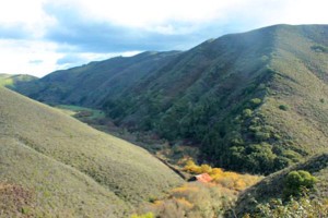
The Irish Hills Coastal Watersheds are located in the San Luis Range, along the remote San Luis Obispo County coastline between the communities of Los Osos and Avila Beach. The drainages rise to a maximum elevation of 1,819 feet above sea level at Saddle Peak. The major creeks flowing to the Pacific Ocean and with their headwaters in the Coastal Range Mountains are Hazard Canyon, Islay Creek, Coon Creek, Diablo Creek, Irish Creek, Rattlesnake Creek, Hanford Creek and Wild Cherry Canyon. The watershed is dominated by grazing lands some in conservation or agricultural easements and public lands. Other land uses include a regional nuclear power plant, passive recreation, natural resource preservation and limited oil drilling.
WATERSHED OVERVIEW
|
Hydrologic Unit Name:
|
Estero Bay HU 10
|
|
Water Planning Area:
|
San Luis Obispo/ Avila WPA 6
|
|
Acreage:
|
27,922 acres
|
|
Flow to:
|
Pacific Ocean
|
|
Groundwater Basin(s):
|
None
|
|
Jurisdictions:
|
County of San Luis Obispo, CA Department of Parks and Recreation
|
|
Watershed Plans:
|
Irish Hills Coastal Watershed Conservation Plan (Coastal Conservancy, 2001)
|
Full Data Snapshot
Download the Watershed Snapshot for more detailed information such as:
- Rainfall
- Geology
- Hydrology models
- Vegetation
- Special status wildlife and plants
- Land use
- Demographics
- Major changes in the watershed
- Watershed health
- Groundwater