Cuyama Valley Groundwater Basin
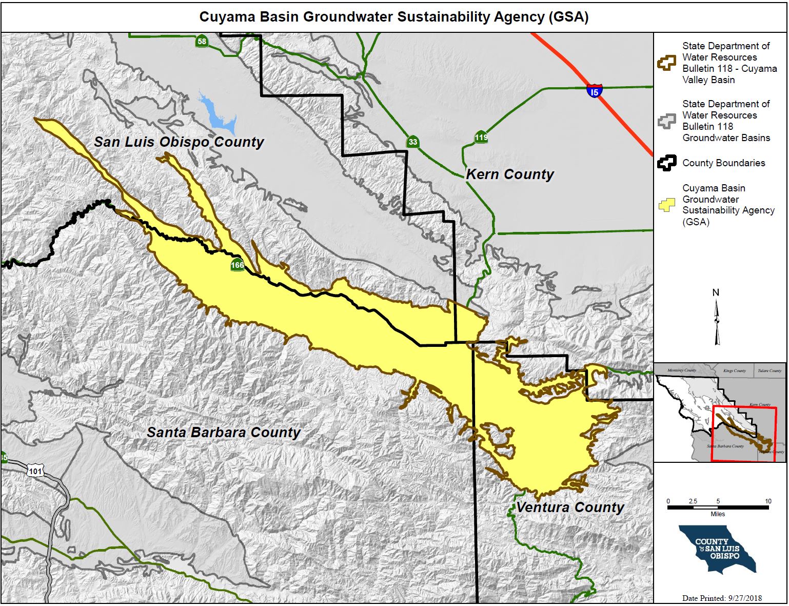
The Cuyama Valley Groundwater Basin, DWR Bulletin 118 Basin No. 3-13, is situated between the Caliente Range to the north and the Sierra Madre Mountains to the southwest. The valley trends east and is drained by the Cuyama River which is the primary source of recharge to the groundwater basin. The basin overlies an area of approximately 147,200 acres (230 square miles) which extends into four counties, including San Luis Obispo County, Santa Barbara County, Kern County, and Ventura County. The basin area in San Luis Obispo County is approximately 32,600 acres (51 square miles).
Cuyama Basin Groundwater Sustainability AgencyThe Cuyama Basin GSA (CBGSA) formed through a Joint Power Agreement (JPA) and submitted the required information on June 12, 2017 to DWR to initiate the 90 day period to become a groundwater sustainability agency. The CBGSA includes the County of San Luis Obispo, the County of Ventura, the County of Kern, Santa Barbara County Water Agency, Cuyama Basin Water District (CBWD), and Cuyama Community Services District. The CBGSA is represented by an eleven (11) member Board of Directors. On May 23, 2017, the County of San Luis Obispo Board of Supervisors appointed the District 4 Supervisor, Lynn Compton, as the director representing the County and the District 5 Supervisor, Debbie Arnold, as the alternate director representing the County. For more information on the Cuyama Basin, please visit https://cuyamabasin.org/ |
Groundwater Sustainability Plan & Annual Reporting |
Meeting InformationThe Cuyama Basin GSA (CBGSA) Board of Directors hold regular meetings on the 1st Wednesday of every month starting at 4:00 PM. The regular meeting location is the Cuyama Family Resource Center at 4689 CA-166 in New Cuyama, CA. Click here to view the Meeting Calendar and past events. Agendas and agenda packets are viewable at https://cuyamabasin.org/board-of-directors |
How do I get involved?
|
Interactive Map of the Cuyama Groundwater Basin within SLO CountyClick the link above to access the SGMA Interactive Data Viewer for the Cuyama Groundwater Basin! This is an interactive mapping system to help you to navigate around the Cuyama Groundwater Basin by panning, zooming, or searching for a specific parcel or street address that you would like to locate. There are different map layers that can be shown and superimposed in this interactive mapping system such as boundaries of groundwater basins, cities, roads, SGMA eligible entities, and others by checking the layer names indicated on the left panel layer menu. To search and locate a specific APN or street address on the map:
|
Sign up for the SGMA Mailing ListClick here to subscribe to the County's SGMA email notification list! |


