Paso Basin Aerial Groundwater Mapping Pilot Study
The County of San Luis Obispo was selected for a pilot study to collect geophysical mapping data in a portion of the Paso Robles Basin (click for map of study area). The successful pilot study used innovative technology called Aerial Electromagnetic Method (AEM) to collect geophysical data in the Paso Robles Basin. The data from this pilot study will be used to enhance groundwater modeling efforts and provide a better picture of our groundwater system.
Project Status Update
On November 7, 2019, the mapping survey was succesfully completed over the Paso Robles Basin. Survey reports are available to review in the table below.
|
Report |
Description |
Link |
|
Hydrogeologic Conceptual Model in Paso Robles, Traditional HCM Report |
This report was prepared to improve the understanding of the hydrology in the central portion of the Paso Robles Basin based on geophysical data collected in November 2019. |
Click here to view the report |
|
October 2020: Draft Data Report SkyTEM Survey, Paso Robles Basin by SkyTEM Airborne Surveys Worldwide |
This report covers data acquisition, technical specifications, data processing and presentation of the SkyTEM312M survey flown in November 2019 in the Paso Robles Basin, CA. |
|
| Multipoint Statistical Report: Application of a multipoint method to assess potential recharge areas in San Luis Obispo County, California, U.S.A. | The MPS report discusses the application of a multipoint statistics method to assess potential recharge areas in Pilot Study area in the Paso Robles Basin. | Click here to view this report |
DWR's Upcoming AEM Surveys
The Department of Water Resources is conducting airborne electromagnetic (AEM) surveys in California’s high- and medium-priority groundwater basins, where data collection is feasible, to assist local water managers as they implement the Sustainable Groundwater Management Act (SGMA) to manage groundwater for long term sustainability.
Watch this short video (https://youtu.be/bT4jBVilTvU) to learn more about the AEM geophysical method, or visit DWR's AEM project webpage: water.ca.gov/programs/SGMA/AEM
For questions and additional information, please email DWR at [email protected].
Informational Presentations
Paso Basin Cooperative Committee Meeting - April 28, 2021 @ 4:00 p.m.
Agenda item 7 - Receive presentation on Paso Basin Aerial Groundwater Mapping Pilot Study
- Click here to view the agenda and staff report
County Board of Supervisors Meeting - April 20, 2021 @ 9:00 a.m.
Agenda item 35 - Receive and file a presentation of the Paso Basin Aerial Groundwater Mapping Pilot Study
- Click here to view the staff report and supporting documents
AEM Flight Demonstration
The video below provides an overview of AEM technology and demonstrates how this type of groundwater mapping technology is used. (Video: Stanford University)
Related Documents
- Hydrogeologic Conceptual Model in Paso Robles, Traditional HCM Report »
- Multipoint Statistical Report »
- October 2020: Draft Data Report »
FAQs
The Paso Basin Pilot Study will use aerial groundwater mapping technology to characterize the subsurface geology and better understand where groundwater occurs and flows, which is necessary for the refinement of the hydrogeologic model of the Paso Basin.
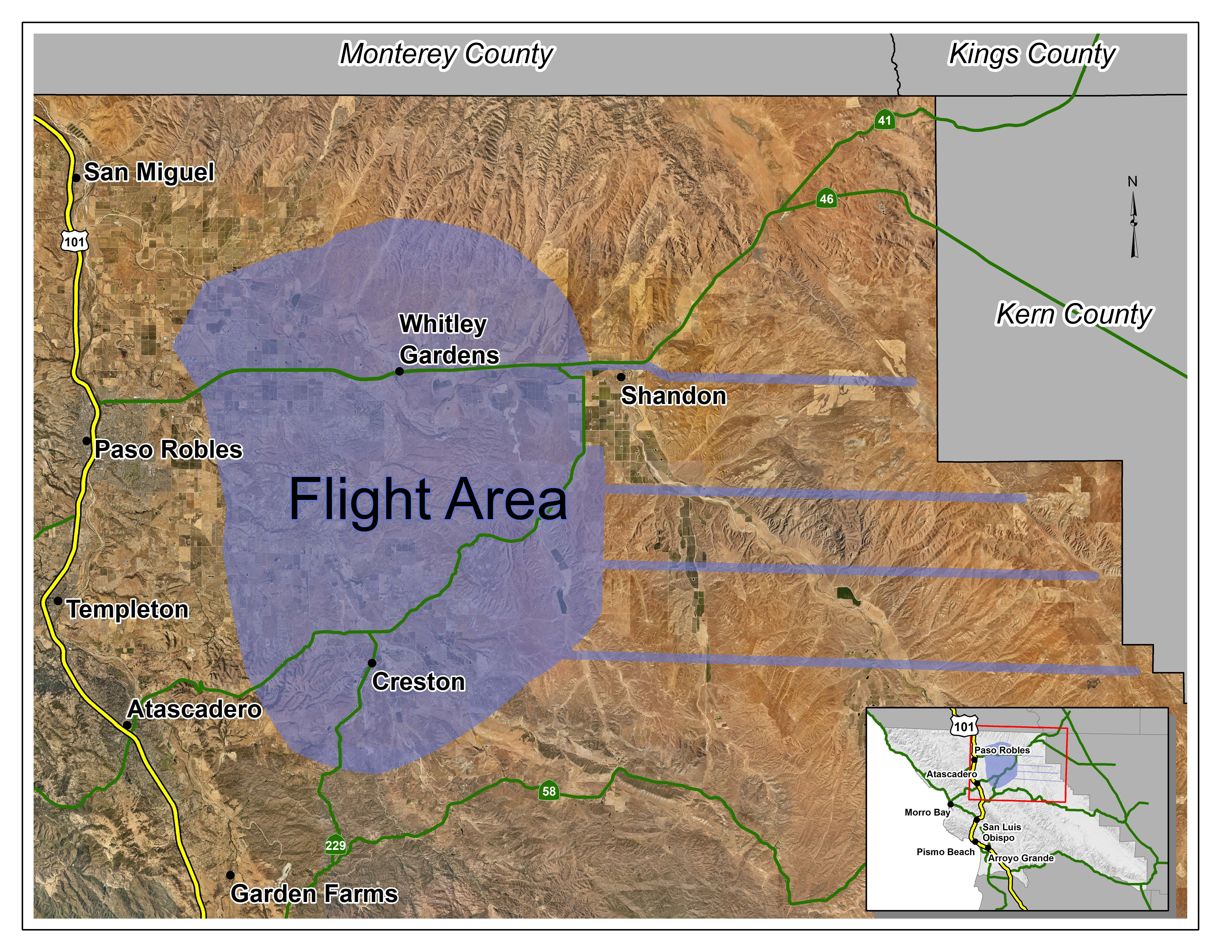
Instruments attached to a low flying helicopter (~100 feet above the ground surface) towing a large hoop will transmit a weak electromagnetic field. This field interacts with the ground, and the response from the ground is measured using a set of receiver coils attached to the hoop. The helicopter flies back and forth along regularly spaced lines and will cover a distance of of approximately 497 miles. The instrument can collect data to a depth of about 1400 feet below ground. Once combined and calibrated with well data and existing knowledge of the subsurface conditions, this dataset can be used to map out the layering of “course” materials (sand and gravel), “fine” materials (silts and clay) and bedrock to show the structure of the basin and groundwater system. This new knowledge will help guide placement of new monitoring wells or identification of recharge locations.
The map below shows the general area of the flight paths where data will be surveyed, approximately 497 line-miles (800 kilometers) over the Paso Basin. The study will take place in two areas of the Paso Robles Basin, on the east side of the valley, and the area near Highway 46 and Highway 229 by Creston and Whitley Gardens. The helicopter will fly in and out of the Paso Robles Municipal Airport for refueling between production flights.
Is it Safe?
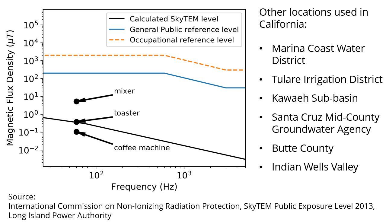
This project does not pose a risk to health or safety. The very low level of magnetic exposure is about the same as standing one foot from a toaster, as shown on the Figure below [see note 1].
The AEM transmitter generates a magnetic field that is lower than 1/100th of the accepted general public exposure level across all frequencies [see note 2].
The same AEM surveys have been conducted in other location throughout California with no reported ill effects to humans or animals.
Notes:
[1] Long Island Power Authority: https://www.lipower.org/
[2] International Commission on Non-Ionizing Radiation Protection. "Guidelines for limiting exposure to time-varying electric and magnetic fields (1 Hz to 100 kHz)." Health physics 99.6 (2010): 818-836.
The State of California signed a landmark agreement to form a partnership with the Kingdom of Denmark to share the latest technology, research, and techniques for water resources management. This Pilot Study presents an opportunity for our community to benefit from this partnership by obtaining a better understanding of our groundwater system.
Project Leads:
- Stanford University
- California Department of Water Resources
- Kingdom of Denmark
Other Partners:
- San Luis Obispo County
- Butte County
- Indian Wells Valley County
Funding Sources:
- California Department of Water Resources
- State Water Resources Control Board
- Kingdom of Denmark
- Project Partners
In 2017, Stanford University Professor Rosemary Knight spearheaded a project to map underground freshwater resources and forecast the intrusion of saltwater into aquifers beneath the California coastal town of Marina. An overview of this project, which was a collaboration between Stanford, the Marina Coastal Water District, and Aqua Geo Frameworks, can be seen in the video at the top of this page.
Other California locations where AEM studies have been completed:
- Marina Coast Water District
- Tulare Irrigation District
- Kawaeh Sub-basin
- Santa Cruz Mid-County Groundwater Agency
- Butte County Indian
- Wells Valley
For questions or additional information, please contact DWR at [email protected], or visit DWR’s AEM Project website: https://bit.ly/36iM3Wo.