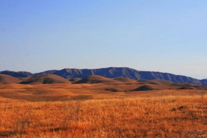
Cholame Creek
Description
 Cholame Creek Watershed
The Cholame Watershed is located in the North easterly portion of San Luis Obispo County and crosses the county line entering Monterey County to the North. 47,300 acres of the total 151,701 acres are located in SLO County. The watershed is drained by Cholame Creek and its tributaries southeastward and westward into the Estrella River (a tributary to the Salinas River) with the confluence of the Estrella River and Cholame Creek occurring at the town of Shandon. The Cholame Creek watershed is a lightly-populated rural setting and drains into an alluvial valley and surrounding mountains within an ecosystem characterized of grassland, chaparral, oak woodland, and sagebrush and minor amounts of cropland, primarily consisting of grain or hay crops. The dominant land use is agriculture. The area around Shandon Valley is generally used most intensively for agriculture because of better soils and water availability. Irrigated production has increased during the last 10 years, particularly in vineyards and alfalfa. Dry farming and grazing operations encompass the rest of the agricultural uses. The highest watershed elevation within the County limits is at approximately 2,476-feet with the lowest elevation occurring at approximately 1,017-feet. The watersheds headwaters are in Diablo Range in Monterey County.
WATERSHED OVERVIEW
|
Hydrologic Unit Name: |
Estrella 17 |
|
Water Planning Area: |
Cholame WPA 15 |
|
Acreage: |
151,701 acres total / 47,300 acres in San Luis Obispo County |
|
Flow to: |
Estrella River– to Salinas River and Pacific Ocean (Monterey bay National Marine Sanctuary) |
|
Groundwater Basin(s): |
Paso Robles |
|
Jurisdictions: |
County of San Luis Obispo, Shandon (ptn) |
|
Watershed Plans: |
None |
Full Data Snapshot
Download the Watershed Snapshot for more detailed information such as:
- Rainfall
- Geology
- Hydrology models
- Vegetation
- Special status wildlife and plants
- Land use
- Demographics
- Major changes in the watershed
- Watershed health
- Groundwater
